Application of Remote Sensing and Geoinformatics Techniques in Erosion Mapping and Groundwater Management in the River Amba Watershed, Central Nigeria
Keywords:
Erosion, River Amba , Watershed, Landsat imagery, GISAbstract
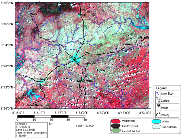
This research integrated easy-to-handle remote sensing data and geoinformatics techniques for erosion mapping and groundwater management in the River Amba watershed, central Nigeria. It is aimed at: (a) the determination of the erosion-prone areas and (b) the estimation of the groundwater potential contamination risk under current and future anthropogenic activities. Rainfall intensity was evaluated from monthly rainfall data (2001 - 2011) from the station located within the River Amba Watershed. Digital Elevation Model (DEM) for the terrain was created using the 3D Analyst tool (Surfer 14) and was used to determine the flow direction and lineament features in each raster cells. Remote sensing data (aerial photographs and LANDSAT imagery) were used to develop a land-use map, while geological mapping was used to determine the local geology of the watershed area. The contributions of the various factors to the erosion hazardous areas are: elevation 31.49 %, land use 21 %, slope 14 %, geology 12.52 %, rainfall intensity 10.5 % and flow accumulation 10.5 %. The combined influences of these factors to erosion susceptibility as either: very high, high, moderate, low, and very low with the south-western part characterized as high while other parts of the study area moderate to very low erosion vulnerability. The groundwater level is shallow (4.0 –28.5 m) and discharges through the Amba river and many springs. These springs along with boreholes and wells supply drinking water to Lafia and the environs.
Published
How to Cite
Issue
Section
Copyright (c) 2021 Journal of the Nigerian Society of Physical Sciences

This work is licensed under a Creative Commons Attribution 4.0 International License.
How to Cite
Similar Articles
- M. A. Okono, E. P. Agbo, B. J. Ekah, U. J. Ekah, E. B. Ettah, C. O. Edet, Statistical Analysis and Distribution of Global Solar Radiation and Temperature Over Southern Nigeria , Journal of the Nigerian Society of Physical Sciences: Volume 4, Issue 3, August 2022
- Mahouton Justine Carine ADJASSA, Gabin KOTO N'GOBI, Hagninou Elagnon Venance DONNOU, Clément Adéyèmi KOUCHADE, Basile Bruno KOUNOUHEWA, Generation of Electricity From a Hydraulic Turbine in the Djonou River (Benin) , Journal of the Nigerian Society of Physical Sciences: Volume 5, Issue 2, May 2023
- Solomon Nehemiah Yusuf, Williams Midala Wakili, Geological mapping and structural analysis from satellite imagery of a section of the Adamawa Massif: Implications for mineralization , Journal of the Nigerian Society of Physical Sciences: Volume 7, Issue 3, August 2025
- A. K. Usman, Y. A. Hassan, A. A. Bery, A. S. Akingboye, M. D. Dick, B. M. Ahmed, R. O. Aderoju, Hybrid deep belief network and fuzzy clustering approach for geothermal prospectivity mapping in northeastern Nigeria using magnetic and landsat data , Journal of the Nigerian Society of Physical Sciences: Volume 8, Issue 1, February 2026
- Emmanuel P. Agbo, Golden C. Offorson, Abubakar S. Yusuf, John O. Bassey, Moses A. Okono, Ugochukwu Nkajoe, Patrick O. Ushie, Innovative trend analysis of precipitation changes over Nigeria: A case study of locations across the Niger and Benue Rivers , Journal of the Nigerian Society of Physical Sciences: Volume 7, Issue 1, February 2025
- Chinedu L. Udeze, Idongesit E. Eteng, Ayei E. Ibor, Application of Machine Learning and Resampling Techniques to Credit Card Fraud Detection , Journal of the Nigerian Society of Physical Sciences: Volume 4, Issue 3, August 2022
- Emmanuel G. Ndoma, Nyakno J. George, Aniekan M. Ekanem, Muyiwa M. Orosun, Patrick O. Ushie, Emmanuel P. Agbo, Benson E. Eze, Charles C. Mbonu, Kolawole E. Adesina, Blessed Yahweh, Francis E. Okon, Evaluating the health risks of radionuclides in welding and fabrication workshops in Akwa Ibom State, Southern Nigeria , Journal of the Nigerian Society of Physical Sciences: Volume 7, Issue 3, August 2025
- B. O. Eyenubo, V. O. Peretomode, F. Egharevba, S. A. Osakwe, O. G. Avwioro, Polychlorinated biphenyls (PCBs) in sediments and fish from dredged tributaries and creeks of river Ethiope, South-South, Nigeria: sources, risk assessment and bioaccumulation , Journal of the Nigerian Society of Physical Sciences: Volume 6, Issue 2, May 2024
- R. El chaal, M. O. Aboutafail, Statistical Modelling by Topological Maps of Kohonen for Classification of the Physicochemical Quality of Surface Waters of the Inaouen Watershed Under Matlab , Journal of the Nigerian Society of Physical Sciences: Volume 4, Issue 2, May 2022
- Boukary Damiba, Christian Zoundi, Abdoul Kader Segda, Dynamics of the Earth’s magnetopause’s subsolar location during solar cycle 24 in relation to the phases of geomagnetic storms of CME origin , Journal of the Nigerian Society of Physical Sciences: Volume 8, Issue 1, February 2026
You may also start an advanced similarity search for this article.