Geological mapping and structural analysis from satellite imagery of a section of the Adamawa Massif: Implications for mineralization
Keywords:
Geologic Mapping, lineament, satellite, imagery, joints and mineralsAbstract
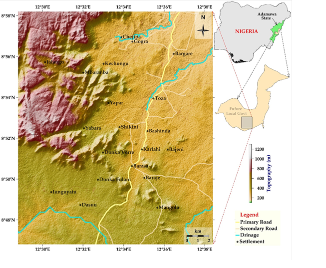
This study provides a comprehensive geological mapping and structural analysis of lithological units within a portion of the Adamawa Massif in northeastern Nigeria, emphasizing their implications for mineralization. Using a scale of 1:50,000, we identified ten distinct lithological units, predominantly belonging to the Older Granites suite, which reflect the Pan?African Orogeny. Lineament density was quantified as the number of lineaments per grid?unit area and classified into nine spectral bands ranging from 0 to 4. The 214 km2 study area was divided into 15 equal grid cells. Four of these cells, located in the northwestern mountain ranges, exhibit high lineament density and encompass 57.08 km2 (26.7 % of the total area). In contrast, the remaining eleven cells, characterized by low lineament density, cover 156.97 km2 (73.3 %). The highest?density category (Band 7) occupies only 14.27 km2, amounting to 10 % of the study area. Structural trends in the region are primarily NNW–SSE and NNE–SSW within the banded gneiss, and NNW–SSE and N–S within the medium-grained granite. These joint systems serve as potential conduits for mineralizing fluids, underscoring the area’s prospective mineral resources.
Published
How to Cite
Issue
Section
Copyright (c) 2025 Solomon Nehemiah Yusuf, Williams Midala Wakili

This work is licensed under a Creative Commons Attribution 4.0 International License.
How to Cite
Similar Articles
- Aliyu Itari Abdullahi, Nuhu Degree Umar, Application of Remote Sensing and Geoinformatics Techniques in Erosion Mapping and Groundwater Management in the River Amba Watershed, Central Nigeria , Journal of the Nigerian Society of Physical Sciences: Volume 3, Issue 2, May 2021
- Catherine N. Ogbizi-Ugbe, Osowomuabe Njama-Abang, Samuel Oladimeji, Idongetsit E. Eteng, Edim A. Emanuel, Synergistic intelligence: a novel hybrid model for precision agriculture using k-means, naive Bayes, and knowledge graphs , Journal of the Nigerian Society of Physical Sciences: Volume 8, Issue 1, February 2026
- A. K. Usman, Y. A. Hassan, A. A. Bery, A. S. Akingboye, M. D. Dick, B. M. Ahmed, R. O. Aderoju, Hybrid deep belief network and fuzzy clustering approach for geothermal prospectivity mapping in northeastern Nigeria using magnetic and landsat data , Journal of the Nigerian Society of Physical Sciences: Volume 8, Issue 1, February 2026
- Afizu Mamudu, Eti-mbuk S. Akanbi, Shola C. Odewumi, Hydrothermal alteration and mineral potential zones of Bauchi area Northeastern Nigeria using interpretation of aeroradiometric data , Journal of the Nigerian Society of Physical Sciences: Volume 7, Issue 1, February 2025
- Yusuf Ibrahim, Common Fixed Point Theorems for Multivalued Generalized F-Suzuki-Contraction Mappings in Complete Strong b-Metric Spaces , Journal of the Nigerian Society of Physical Sciences: Volume 1, Issue 3, August 2019
- S. Iyakwari, H. J. Glass, G. K. Rollinson, A. A. Umbugadu, O. D. Opaluwa, B. O. Frankie, Validation of Near InfraRed preconcentration strategies for ore sorting , Journal of the Nigerian Society of Physical Sciences: Volume 4, Issue 1, February 2022
- Yusuf Olanrewaju Saheed, Mufutau Abiodun Salawu, Aderemi Babatunde Alabi, Mechanical Evaluation and Minerals Phases Identification of Fine and Coarse Okelele Block Clay Composites for Furnace Lining Application , Journal of the Nigerian Society of Physical Sciences: Volume 4, Issue 1, February 2022
- Bethel Onyeka Ekute, Muluh Emmanuel Khan, Aloysius Akaangee Pam, Jude Ehwevwerhere Emurotu, Assessment of the nutritional and phytochemical composition of selected mushroom species grown in Southern Nigeria , Journal of the Nigerian Society of Physical Sciences: Volume 7, Issue 4, November 2025
- K. N. Babu, S. Meenakshi, Even vertex odd edge root square mean labeling of some cycle-related graphs , Journal of the Nigerian Society of Physical Sciences: Volume 8, Issue 3, August 2026 (In Progress)
- N. D. Umar, O. V. Omonona, C. O. Okogbue, Groundwater Quality Assessment Using Multivariate Analysis and Water Quality Index in some Saline Fields of Central Nigeria , Journal of the Nigerian Society of Physical Sciences: Volume 3, Issue 4, November 2021
You may also start an advanced similarity search for this article.
Most read articles by the same author(s)
- Rhoda Bernard Gusikit, Solomon Nehemiah Yusuf, Hyeladi Usman Dibal, Victor Bulus Diyelmak, Ahmed Isah Haruna, Comparative analysis of lithium enrichment mechanisms in aquifers in the Benue Trough , Journal of the Nigerian Society of Physical Sciences: Volume 7, Issue 3, August 2025